New Zealand Geography
New Zealand is made up of two main islands – commonly known as the North and South Islands – surrounded by many smaller islands.
The two islands are separated by the Cook Strait. New Zealand’s total area is slightly smaller than Italy or Japan, and a little larger than the United Kingdom. New Zealand’s neighbors include Australia to the northwest and the Pacific islands of Tonga and Fiji to the north. The South Island is the larger of the two main isles. It is a mountainous island, divided down the center by the Southern Alps. The tallest peak is Mount Cook, or Aoraki, which measures 12,320 feet [Source: Wikipedia.com]. The mountains enjoy snow from June through to the end of October, making them a popular choice for skiers and snowboarders. The South Island is also characterized by stunning glaciers. The smaller North Island has fewer mountains, but many of its peaks are volcanoes. In fact, the North Island’s highest summit, Mount Ruapehu is an active volcano.
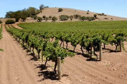
Half of New Zealand’s land is made up of clear open pastures, so it’s not surprising to learn that around 15% of the country is used for agricultural purposes.
Sheep and cattle are farmed around Hamilton and New Plymouth on the North Island, and in Dunedin and Invercargill on the South. While New Zealand’s history of animal farming extends back to the late 19th century, the country’s wine industry is a more recent development. Today New Zealand’s wine industry is one of the world’s largest, with the country’s ten major wine regions spanning some 1000 miles. New Zealand’s dramatic landscapes have made it a popular choice for filming many television programs and Hollywood blockbusters, including the Lord of the Rings trilogy and The Last Samurai.